Archivo:Cape canaveral.jpg

Este archivo es de Wikimedia Commons y puede usarse en otros proyectos. La descripción en su página de descripción del archivo se muestra debajo.
Resumen
| DescripciónCape canaveral.jpg |
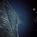
English: Cape Canaveral, Florida and the NASA John F. Kennedy Space Center are shown in this near-vertical photograph. Numerous launch pads line the Atlantic Ocean coast near the center of the photograph. To the north of the multiple launch pads, the Space Shuttle landing runway, the Shuttle Assembly Area, and Shuttle Launch Pads A and B are visible. To the south of the multiple launch pads are Port Canaveral and the city of Cocoa Beach, Florida. To the west of the space complex, five causeways span the Indian and Banana Rivers. Interstate Highway 95 is the main artery traversing south to north just west of the Florida cities of Cocoa and Titusville. |
|||
| Fecha | ||||
| Fuente | Gateway to Astronaut Photography of Earth (image link) | |||
| Autor | NASA | |||
| Permiso (Reutilización de este archivo) |
|
|||
| Otras versiones |
Cape canaveral crop.jpg: |
| Ubicación del objeto | 28° 30′ 00″ N, 80° 30′ 00″ O | Ubicación de esta y otras imágenes en: OpenStreetMap |
|---|
| Posición de la cámara | 28° 18′ 00″ N, 79° 18′ 00″ O | Ubicación de esta y otras imágenes en: OpenStreetMap |
|---|
Este archivo fue catalogado por Johnson Space Center de la Administración Nacional de Aeronáutica y del Espacio (NASA) de los Estados Unidos de Américabajo el identificador de foto: STS043-084-031.Esta etiqueta no indica el estado de los derechos de autor del trabajo adjunto. Se requiere una etiqueta de derechos de autor normal. Para más información vea Commons:Sobre las licencias. Otros idiomas:
العربية ∙ беларуская (тарашкевіца) ∙ български ∙ català ∙ čeština ∙ dansk ∙ Deutsch ∙ English ∙ español ∙ فارسی ∙ français ∙ galego ∙ magyar ∙ հայերեն ∙ Bahasa Indonesia ∙ italiano ∙ 日本語 ∙ македонски ∙ മലയാളം ∙ Nederlands ∙ polski ∙ português ∙ русский ∙ sicilianu ∙ slovenščina ∙ Türkçe ∙ українська ∙ 简体中文 ∙ 繁體中文 ∙ +/− |
|
Esto es una imagen de un lugar o edificio incluido en el Registro Nacional de Lugares Históricos de los Estados Unidos. Su número de referencia es 84003872. |
| Annotations InfoField | This image is annotated: View the annotations at Commons |
Launch Complex 39A, used for Saturn V, the Space Shuttle, Falcon 9, and Falcon Heavy launches.
Launch Complex 39B, used for Saturn V, the Space Shuttle, and Ares I-X launches.
Kennedy Space Center industrial area
Space Launch Complex 41, used for Titan III, Titan IIIE, Titan IV, and Atlas V launches.
Space Launch Complex 40, used for Titan III, Titan IV, and Falcon 9 launches.
Space Launch Complex 37, used for Saturn I, Saturn IB, and Delta IV launches.
Launch Complex 26, the launch site for Explorer 1, the first American successful satellite.
Launch Complexes 10, 31, and 32. LC-31 was used as a burial vault for the remains of the Space Shuttle Challenger.
The "Missile Row", used for Atlas and Titan launches and Falcon 9 landings.
Landing Zones 1 and 2 (formerly Launch Complex 13), used for Atlas launches and Falcon 9 landings.
Leyendas
Elementos representados en este archivo
representa a
STS-43 inglés
7 ago 1991
28°18'N, 79°18'W
28°30'N, 80°30'W
STS043-084-031
image/jpeg
b728acc4b15c6938a58eb3f9ade879448135b8a9
8 163 743 byte
5266 píxel
5320 píxel
Historial del archivo
Haz clic sobre una fecha/hora para ver el archivo a esa fecha.
| Fecha y hora | Miniatura | Dimensiones | Usuario | Comentario | |
|---|---|---|---|---|---|
| actual | 20:35 21 mar 2009 |  | 5320 × 5266 (7,79 MB) | Jhf | Same image with greater resolution |
Usos del archivo
La siguiente página enlaza a este archivo: