Archivo:Chesapeake and Delaware Canal eastern entrance.jpg
De LibreFind

Tamaño de esta previsualización: 800 × 527 píxeles. Otras resoluciones: 320 × 211 píxeles | 640 × 422 píxeles | 1024 × 674 píxeles | 1500 × 988 píxeles.
Archivo original (1500 × 988 píxeles; tamaño de archivo: 527 KB; tipo MIME: image/jpeg)
| Descripción |
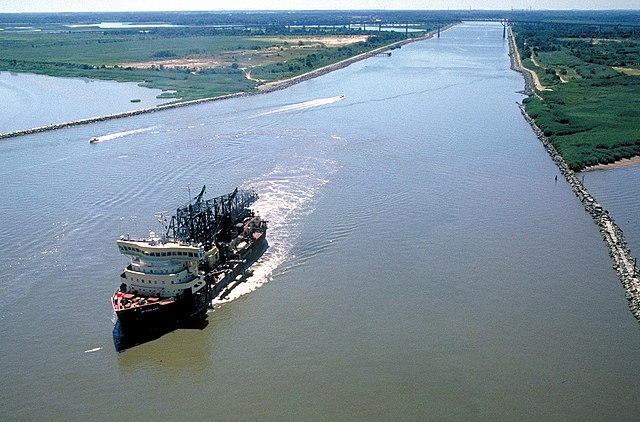
English: The eastern entrance to the Chesapeake & Delaware Canal at Reedy Point, Delaware. Fort Dupont State park is at the right. The Reedy Point Bridge, carrying Delaware State Route 9, is visible in the distance. The U.S. Army Corps of Engineers hopper dredge McFarland is exiting the channel. View is to the east. The channel entrance is located on the Delaware River in New Castle County, Delaware, USA.
|
|||
| Fecha | not specified or unknown | |||
| Fuente |
U.S. Army Corps of Engineers Digital Visual Library Image page Image description page Digital Visual Library home page |
|||
| Autor | Anthony Bley, U.S. Army Corps of Engineers | |||
| Permiso (Reutilización de este archivo) |
|
|||
| Localización | Delaware River, New Castle County, Delaware, USA |
| Posición de la cámara | | Ubicación de esta y otras imágenes en: OpenStreetMap |
|---|
Historial del archivo
Haz clic sobre una fecha/hora para ver el archivo a esa fecha.
| Fecha y hora | Miniatura | Dimensiones | Usuario | Comentario | |
|---|---|---|---|---|---|
| actual | 04:46 8 abr 2007 | | 1500 × 988 (527 KB) | DanMS | {{Information | Description = {{en|The eastern entrance to the Chesapeake & Delaware Canal at Reedy Point, Delaware. Fort Dupont State park is at the right. The Reedy Point Bridge, carrying Delaware State Route 9, is visible in the distance. The U. |
Usos del archivo
La siguiente página enlaza a este archivo: