Archivo:Interstate Highway status unknown date.jpg
De LibreFind

Tamaño de esta previsualización: 800 × 473 píxeles. Otras resoluciones: 320 × 189 píxeles | 640 × 378 píxeles | 1024 × 605 píxeles | 1280 × 757 píxeles | 2197 × 1299 píxeles.
Archivo original (2197 × 1299 píxeles; tamaño de archivo: 566 KB; tipo MIME: image/jpeg)
| Descripción |
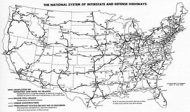
English: c. 1963 Interstate Highway status map |
| Fecha | hacia 1963 |
| Fuente | Federal Highway Administration (1976). America's Highways 1776–1976: A History of the Federal-Aid Program. Washington, DC: United States Department of Transportation. p. 277 OCLC 3280344. |
| Autor | Federal Highway Administration |
| Permiso (Reutilización de este archivo) |
Public domain |
| This image is a work of a United States Department of Transportation employee, taken or made as part of that person's official duties. As a work of the U.S. federal government, the image is in the public domain. |
- Dating this map
- Doesn't have I-27 - "DOT Letter dated 12/24/1968; Adm. Cir. 08-1969, dated 02/01/69."
- Has I-80S across Pennsylvania - became I-76 February 26, 1964
- I-15 ends at I-10 - extended December 1968
- I-80 goes via southern Cleveland - unsure when moved
- Judging by I-75 in Michigan, it's after fall 1962 and before the end of 1963
| Interstate Highway System planning maps | ||
|---|---|---|
| June 27, 1958 | Ca. 1963 | March 30, 1970 |
Historial del archivo
Haz clic sobre una fecha/hora para ver el archivo a esa fecha.
| Fecha y hora | Miniatura | Dimensiones | Usuario | Comentario | |
|---|---|---|---|---|---|
| actual | 10:15 27 dic 2005 | | 2197 × 1299 (566 KB) | SPUI~commonswiki | {{PD-USGov}} Interstate Highway status map from page 277 of ''America's Highways 1776-1976'' by the U.S. Department of Transportation Federal Highway Administration. Map Category:road maps |
Usos del archivo
La siguiente página enlaza a este archivo: