Archivo:NASA Radar 3-D View of San Andreas Fault.jpg

De LibreFind
Saltar a: navegación, buscar
Archivo original(2984 × 2737 píxeles; tamaño de archivo: 7,6 MB; tipo MIME: image/jpeg)

Este archivo es de Wikimedia Commons y puede usarse en otros proyectos. La descripción en su página de descripción del archivo se muestra debajo.

Resumen

Descripción
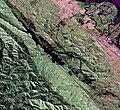
English: Much of the length of the San Andreas Fault is lined by a distinct trough. This false-colour radar image shows a section of the fault west of San Francisco Bay; the Crystal Springs Reservoir fills the trough that marks the underlying fault. The black line curving along the east side of the fault is I-280, and California highway 92 runs from the top right across to the centre left of the image, heading towards Half Moon Bay to the west. San Mateo and Burlingame are parts of the large urbanized area in various tones of pink and green, and Foster City is the area of curved streets extending out into the San Francisco Bay at the top right.
Fecha
Fuente NASA Earth Observatory
Autor Image courtesy of the NASA Jet Propulsion Laboratory.

Instrument: Aircraft Sensors - UAVSARS

Licencia

Public domain Este archivo es de dominio público porque fue creado por la NASA. Las políticas sobre copyright de la NASA estipulan que «el material de la NASA no está protegido con copyright a menos que se indique lo contrario». (Políticas sobre copyright de la NASA o Políticas sobre la utilización de imágenes del Jet Propulsion Laboratory).
Advertencias:
  • El uso del logotipo de la NASA (incluidos el logotipo actual y los anteriores) está restringido.
  • El sitio web de la NASA almacena una gran cantidad de imágenes del Programa Espacial de la URSS, de la Agencia Espacial Federal Rusa y otras agencias espaciales no estadounidenses. Estas imágenes no son de dominio público.
  • Material del Telescopio espacial Hubble puede tener copyright si no proviene explícitamente del Space Telescope Science Institute. [1]
  • Todo el material creado por la sonda espacial SOHO está protegido por copyright y requiere permiso para ser utilizado con fines comerciales o no educativos. [2]
  • Las imágenes que figuran en el sitio web Astronomy Picture of the Day (APOD) pueden tener copyright. [3]

Leyendas

Añade una explicación corta acerca de lo que representa este archivo

Elementos representados en este archivo

representa a

Historial del archivo

Haz clic sobre una fecha/hora para ver el archivo a esa fecha.

Fecha y horaMiniaturaDimensionesUsuarioComentario
actual10:27 23 jun 2009Miniatura de la versión del 10:27 23 jun 20092984 × 2737 (7,6 MB)Originalwana{{Information |Description={{en|1=Much of the length of the San Andreas Fault is lined by a distinct trough. This false-colour radar image shows a section of the fault west of San Francisco Bay; the Crystal Springs Reservoir fills the trough that marks th

La siguiente página enlaza a este archivo:

Metadatos