Archivo:Beginning Point of the U.S. Public Land Survey Pennsylvania.jpg

De LibreFind
Saltar a: navegación, buscar
Archivo original(2112 × 2816 píxeles; tamaño de archivo: 3,32 MB; tipo MIME: image/jpeg)

Este archivo es de Wikimedia Commons y puede usarse en otros proyectos. La descripción en su página de descripción del archivo se muestra debajo.

Posición de la cámara40° 38′ 33″ N, 80° 31′ 10″ O Kartographer map based on OpenStreetMap.Ubicación de esta y otras imágenes en: OpenStreetMapinfo
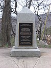
Descripción View of the Pennsylvania side of the Beginning Point of the U.S. Public Land Survey, a monument marking the site that served as the basis for the entire Public Land Survey System — the system by which most of the United States, outside of the original colonies, was surveyed. Located on the Ohio/Pennsylvania border east of downtown East Liverpool, Ohio, it is split between the city of East Liverpool and the borough of Ohioville in Beaver County, Pennsylvania. Erected in 1881 by a joint commission of Ohio and Pennsylvania surveyors, the monument was declared a National Historic Landmark in 1966. The road on which it lies is Ohio State Route 39 and Pennsylvania Route 68.
Fecha Tomada el 28 de marzo de 2009
Fuente Trabajo propio
Autor User:Nyttend
Permiso
(Reutilización de este archivo)
Public domain Yo, el titular de los derechos de autor de esta obra, lo libero al dominio público. Esto aplica en todo el mundo.
En algunos países esto puede no ser legalmente factible; si ello ocurriese:
Concedo a cualquier persona el derecho de usar este trabajo para cualquier propósito, sin ningún tipo de condición al menos que éstas sean requeridas por la ley.
Otras versiones Front and Ohio side of the monument

Leyendas

Añade una explicación corta acerca de lo que representa este archivo

Elementos representados en este archivo

representa a

40°38'33.000"N, 80°31'9.998"W

image/jpeg

4637a521e868c35d733f702d73beb7ad8d33835f

3 478 249 byte

2816 píxel

2112 píxel

Historial del archivo

Haz clic sobre una fecha/hora para ver el archivo a esa fecha.

Fecha y horaMiniaturaDimensionesUsuarioComentario
actual05:30 28 mar 2009Miniatura de la versión del 05:30 28 mar 20092112 × 2816 (3,32 MB)Nyttend{{Location|40|38|33|N|80|31|10|W}} {{Information |Description=View of the Pennsylvania side of the {{w|Beginning Point of the U.S. Public Land Survey}}, a monument marking the site that served as the basis for the entire {{w|Public Land Survey System}} �

La siguiente página enlaza a este archivo:
Metadatos