Archivo:East-Hem 200ad.jpg


|
Esta imagen debería volverse a crear como imágenes vectoriales SVG. Esto proporciona muchas ventajas, véase Commons:Media for cleanup (en inglés) para más información. Si ya hay una versión SVG de esta imagen disponible, por favor súbala a Commons. Tras subirla, reemplace esta plantilla con la plantilla
{{vector version available|nuevo nombre de imagen.svg}} en esta imagen. |


Resumen
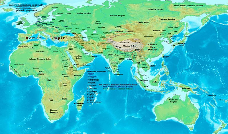
| Descripción | Eastern Hemisphere in 200 AD. |
| Fuente | self-made (For reference information, see the Map Source References section below.) |
| Autor | Thomas Lessman (Contact!) |
| Permiso (Reutilización de este archivo) |
Yo, el titular de los derechos de autor de esta obra, la publico en los términos de la siguiente licencia: Este archivo se encuentra bajo la licencia Creative Commons Genérica de Atribución/Compartir-Igual 3.0.
|
| Otras versiones |
Obras derivadas de ésta: Part of East Hem 200 AD.jpg see East-Hem_200ad.jpg file history on Wikipedia. |
Map Summary
Original Source URL: http://www.thomaslessman.com/History/images/East-Hem_200ad.jpg.
This map of the Eastern Hemisphere in 200 AD was created by Thomas Lessman, based on information from the sources listed below. This map is free for educational use (see Permission info above). When using this map, please mention that it is available for free at www.WorldHistoryMaps.info.
Map Source References
- Remember, sources often conflict with each other. This map is only as accurate as the information that is available to me. To report any errors or to help further this work, please click here, or email Thomas Lessman at talessman@yis.us
References for information contained in this map:
Primary Sources:
- 1. The DK Atlas of World History, 2000 Edition; map of The World in 250 CE, (Pages 46-47).
- 2. History and Commercial Atlas of China; map of Asia in 200 AD; available on Huhai.net.
- 3. Countries of the World, 1-1-136 CE archive copy at the Wayback Machine map available on www.WorldHistoryMaps.com.
- 4. Map of the World in 200 CE, created by Wikimedia's User:Javierfv1212.
I - European Information is derived primarily from this Map of Europe in 200 AD from www.Euratlas.com.
II - Asian Information is derived primarily from:
- Han Dynasty borders are derived from the History and Commercial Atlas of China (see above, #2 under Primary Sources).
- Indian borders are derived from a combination of these sources:
- Wikimedia's map of the World in 200 CE, created by User:Javierfv1212.
- This map of the Countries of the World, 1-1-136 CE archive copy at the Wayback Machine, available on www.WorldHistoryMaps.com.
- Wikimedia's map of Western Kshatrapas (Western Satraps), created by User:PHG.
- Wikimedia's Satavahana Map, created by User:PHG.
- Korean borders derive from this map of Korea-204.png made by Wikipedia User:Historiographer.
- Kushan Empire borders are derived from a mix of the sources below:
- The DK Atlas of World History (see above, #1 under Primary Sources).
- History and Commercial Atlas of China (see above, #2 under Primary Sources).
- Parthian Empire borders derive from:
- History and Commercial Atlas of China (see above, #2 under Primary Sources).
- Wikimedia's map of the World in 200 CE (see above, #4 under Primary Sources).
- Roman borders in Asia, along with borders for states in Iraq and Caucasus Mts, are derived from the Map of Europe in 200 AD from www.Euratlas.com.
III - African Information, and fringe areas like Australia, Siberia, etc. derive from:
- Wikimedia's map of the World in 200 CE, created by User:Javierfv1212.
- The DK Atlas of World History, 2000 Edition; map of The development of complex societies in Africa; (Page 160).
Note: Much of the information in this map was cross-checked with Bruce Gordon's Regnal Chronologies.
Other Maps by Thomas Lessman
| Maps of the eastern hemisphere showing history
Bold dates are available on Wikimedia or Wikipedia. | ||
| Primeval | ||
| Ancient
|
·| 600 BC | 550 BC | 527 BC | 500 BC |
400 BC | ·| 1 AD | 50 AD | 100 AD | 200 AD | 300 AD | | |
| Medieval |
·| 500 AD | 565 AD | 600 AD | 700 AD | | |
| Modern |
·| 1500 AD | · * For historical maps of the whole world, | |
Other Info
Historial del archivo
Haz clic sobre una fecha/hora para ver el archivo a esa fecha.
| Fecha y hora | Miniatura | Dimensiones | Usuario | Comentario | |
|---|---|---|---|---|---|
| actual | 02:22 26 may 2008 | | 3240 × 1903 (734 KB) | Talessman | Corrections to borders in West Asia, India, Southeast Asia, China, and Korea. Added more information based on new references. Other misc. corrections and updates. |
Usos del archivo
La siguiente página enlaza a este archivo: