Archivo:Palouse hills northeast of Walla Walla.jpg
De LibreFind

Tamaño de esta previsualización: 800 × 451 píxeles. Otras resoluciones: 320 × 180 píxeles | 640 × 361 píxeles | 1118 × 630 píxeles.
Archivo original (1118 × 630 píxeles; tamaño de archivo: 589 KB; tipo MIME: image/jpeg)
| Descripción |
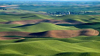
We were hearing a sound like a plane and couldn't figure out where the plane was. Finally one of us spotted a yellow plane flying in the area of the grain elevator! Amazing. Steptoe Butte is the perfect high point in the Palouse Hills to catch the shadow and light play on the hills of the area at sunset and sunrise. This is a morning capture. During one of the ice ages (about 15,000 years ago) Clark Fork River (Montana) was dammed by ice, forming Missoula Lake, the top of which was about 2,000 feet in elevation. About every 2 to 60 years there was thermal erosion of the ice dam and it would collapse and let a flood go through for about 3 days -- whatever time it took to drain Missoula Lake. Many layers of silt left by multiple Missoula floods were topped by loess (dirt blown on top) which made for great rolling hills of farmlands. |
| Fecha | |
| Fuente | Hills, grain elevator, and little yellow plane (really) |
| Autor | Lynn Suckow from Walla Walla, WA, USA |
Licencia
Este archivo se encuentra bajo la licencia Creative Commons Genérica de Atribución/Compartir-Igual 2.0.
- Eres libre:
- de compartir – de copiar, distribuir y transmitir el trabajo
- de remezclar – de adaptar el trabajo
- Bajo las siguientes condiciones:
- atribución – Debes otorgar el crédito correspondiente, proporcionar un enlace a la licencia e indicar si realizaste algún cambio. Puedes hacerlo de cualquier manera razonable pero no de manera que sugiera que el licenciante te respalda a ti o al uso que hagas del trabajo.
- compartir igual – En caso de mezclar, transformar o modificar este trabajo, deberás distribuir el trabajo resultante bajo la misma licencia o una compatible como el original.
| Esta imagen, originalmente subida a Flickr, fue revisada el January 13, 2009 por el administrador o revisor File Upload Bot (Magnus Manske), quien comprobó que el archivo se encontraba disponible en Flickr bajo la licencia nombrada en dicha fecha. |
Historial del archivo
Haz clic sobre una fecha/hora para ver el archivo a esa fecha.
| Fecha y hora | Miniatura | Dimensiones | Usuario | Comentario | |
|---|---|---|---|---|---|
| actual | 17:03 13 ene 2009 | | 1118 × 630 (589 KB) | File Upload Bot (Magnus Manske) | {{Information |Description= We were hearing a sound like a plane and couldn't figure out where the plane was. Finally one of us spotted a yellow plane flying in the area of the grain elevator! Amazing. Steptoe Butte is the perfect high point in the Pa |
Usos del archivo
La siguiente página enlaza a este archivo: