Geographic information system
De LibreFind
| Advanced search |
- About 16 results found and you can help!
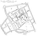
 E. W. Gilbert's version (1958) of John Snow's 1855 map of the Soho cholera outbreak showing the clusters of cholera cases in the London epidemic of 1854 |
Geographic information system (GIS) is a system designed to capture, store, manipulate, analyze, manage, and present all types of geographical data. The acronym GIS is sometimes used for geographical information science or geospatial information studies to refer to the academic discipline or career of working with geographic information systems. In the simplest terms, GIS is the merging of cartography, statistical analysis, and database technology.
- Related: AM/FM/GIS, At-location mapping, Automotive navigation system, Comparison of GIS software, Counter-mapping, Digital geologic mapping, Digital raster graphic, Distributed GIS, Geodesy, Geographic Data Files, Geoinformatics, Geomatics, Geospatial intelligence, GIS and aquatic science, GIS-Centric, GISCorps, GIS Day, GIS in archaeology, Historical GIS, Map database management, Open GIS Consortium, OpenStreetMap, Participatory GIS, Pictometry International, Remote sensing, Shapefile, Traditional knowledge GIS, Virtual globe
| Association of Geographic Information Laboratories... Association of Geographic Information Laboratories for Europe (AGILE) www.agile-online.org - Web |
| Cartography and Geographic Information Society Cartography and Geographic Information Society www.cartogis.org - Web |
| Directions Magazine Directions Magazine www.directionsmag.com - Web |
Gallery for «Geographic information system»
Average relevance
| Federal Geographic Data Committee Federal Geographic Data Committee www.fgdc.gov - Web |
| Geographic Information System (GIS) Educational we... Geographic Information System (GIS) Educational website www.ccdmd.qc.ca/en/gis/ - Web |
| GIS Development GIS Development www.gisdevelopment.net - Web |
| Land Surveyors United Geospatial Social Support Ne... Land Surveyors United Geospatial Social Support Network landsurveyorsunited.com - Web |
| GIS Lounge GIS Lounge gislounge.com - Web |
| GISWiki.NEWS.Reader GISWiki.NEWS.Reader news.giswiki.net - Web |
| GITA GITA www.gita.org - Web |
| International Cartographic Association (ICA) International Cartographic Association (ICA) www.icaci.org - Web |
Low relevance
| National States Geographic Information Council (NS... National States Geographic Information Council (NSGIC) www.nsgic.org - Web |
| Open Forum on Participatory Geographic Information... Open Forum on Participatory Geographic Information Systems and Technologies www.ppgis.net - Web |
| Open Geospatial Consortium, Inc. Open Geospatial Consortium, Inc. www.opengeospatial.org - Web |
| Open Source Geospatial Foundation Open Source Geospatial Foundation www.osgeo.org - Web |
| USGS GIS Poster USGS GIS Poster egsc.usgs.gov/isb/pubs/gis_poster/ - Web |


